
A scroll story · Sognefjord, Norway
How deep is a Norwegian fjord?
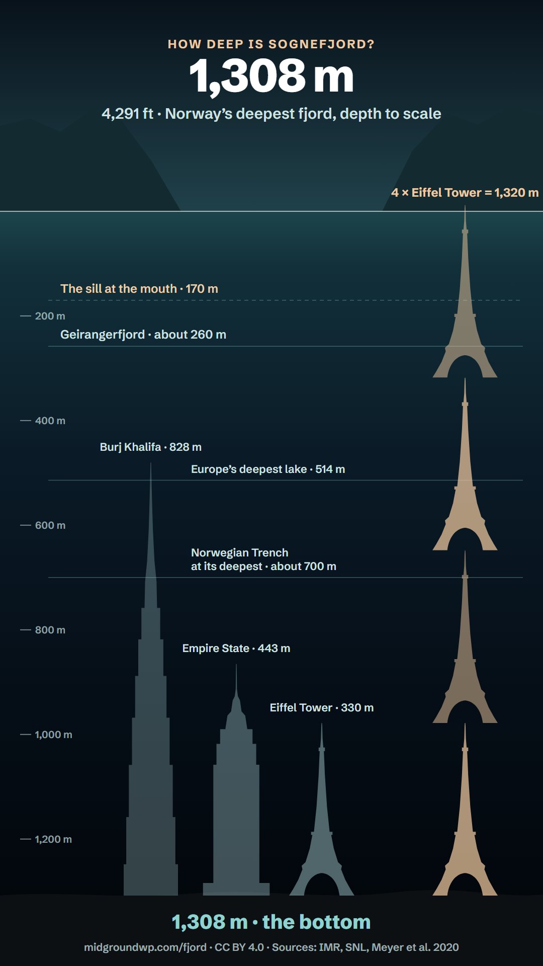
Norway’s deepest fjord, Sognefjord (Sognefjorden in Norwegian), is 1,308 metres (4,291 ft) deep – almost exactly four Eiffel Towers stacked on top of each other. From the surface to the bottom, this page is drawn to scale.
By Pelle Nilsen · 5 October 2026 · 23 sources
The dive: from the surface to 1,308 metres
0–40 m The first 40 metres
Almost everything people do on a fjord happens in this thin band. The top few metres are brackish: river water and meltwater floating on the salt sea. The keel of Icon of the Seas, one of the world’s largest cruise ships, reaches about 9 m down. In summer, the sunlit layer ends just 12–31 m below the surface. Recreational divers stop at 40 m – 3 per cent of the way to the bottom.
170 m The sill
Out at the fjord’s mouth, an underwater ridge rises to only about 170 m below the surface. Below this line, it limits the flow of water from the open sea, which is why the deep basin stays so still. And below about 200 m, there is rarely any useful sunlight anywhere in the sea.
258 m The bottom of Geirangerfjord
Geirangerfjord, which with Nærøyfjord makes up UNESCO’s West Norwegian Fjords World Heritage site, is about 260 m deep at its deepest. Sognefjord still has more than a kilometre to go. Loch Ness, at about 230 m, would fit too.
480 m The top of the Burj Khalifa
Stand the world’s tallest building, 828 m, on the bottom of the fjord, and its tip would still be 480 m under water. Europe’s deepest lake, Hornindalsvatnet, ends just below, at 514 m.
604 m Preikestolen, upside down
Turn the famous cliff above Lysefjord upside down, and its 604 m drop would end about here – far below the bottom of Lysefjord itself, which is more than 400 m deep. Trondheimsfjord bottoms out a little deeper than the cliff, at about 620 m.
700 m Deeper than the sea outside
The sea outside is far shallower. The North Sea averages about 94 m, and even the Norwegian Trench, the deep channel along Norway’s southern and western coast, reaches only about 700 m. Sognefjord goes almost twice as deep.
800 m Life in the dark
Hundreds of metres below the last useful sunlight, the floor is still alive: spindly sea stars and deep-sea squat lobsters live below 800 m, and large glass sponges have been seen at 820 and 930 m.
865 m The top of the Empire State Building
Stand it on the bottom, and its 443 m, antenna included, would reach up to here. Hardangerfjord, Norway’s second-longest fjord, is about 850 m at its deepest.
978 m The top of the Eiffel Tower
Stand Paris’s tower – 330 m with its antennas – on the bottom, and its tip would still be 978 m under water. Stack four of them, and the top one would just break the surface. Around 1,000 m, even the open ocean is completely dark.
1,200 m Hardly any seasons
The water stays at about 7.5 °C all year, as salty as the open sea – so steady, says the researcher Mari Fjalstad Jensen, that you don’t usually notice the seasons. Even so, slow warming has been measured down here.
1,308 m The bottom of Sognefjord
You’ve reached the deepest point of Norway’s deepest fjord, in the middle of the main fjord off Vadheimsfjord, west of Høyanger. The pressure here is about 130 times that at the surface. At 1,270 m, an underwater robot filmed squat lobsters, sea cucumbers and sea stars – and a roundnose grenadier, a fish of the deep ocean. In the drawing, they are far larger than life.
The geology
How a fjord forms – and gets this deep
A fjord is a valley carved below sea level by glaciers, then flooded by the sea. Four steps, seen across the valley (the drawings are not to scale):
Act 1 of 4
It starts as a river valley
Long before the ice ages, rivers cut ordinary valleys into the mountains of western Norway – the valleys that would become today’s fjords.
Act 2 of 4
Then the ice comes – again and again
Over about 2.5 million years, dozens of ice ages sent glaciers down the valleys. Unlike a river, ice can carve below sea level, and it cut deepest inland, where glaciers met and moved fastest. About 20,000 years ago, an ice sheet up to 3 km thick buried all of Norway.
Act 3 of 4
The ice melts, and the sea moves in
As the climate warmed, the ice front retreated up Sognefjord by about 340 m a year. By 9,500 years ago the ice sheet was gone, and the sea had flooded the trough – deep inland, shallow at the mouth, where the ice had spread out and slowed.
Act 4 of 4
What the ice left behind
Smaller glaciers cut the side valleys less deeply, so their floors were left hanging: Nærøyfjord is only 300–400 m deep, while Sognefjord goes down to 1,308 m. And freed of the ice’s weight, the land is still rising – 2–3 mm a year in inner Sogn.
The short answers
Sognefjord in four numbers
How Sognefjord compares
Among Norway’s best-known fjords, the next deepest is Hardangerfjord, at about 850 m. Further afield, plenty goes deeper – the deepest place in the ocean is about eight times as deep. But the fjord has a trick of its own: near Sogndal, the mountains rise so high above it that Store norske leksikon puts the relief at the mountain Bleia at 2,850 vertical metres – about one and a half times the Grand Canyon’s greatest depth.
Free to use under CC BY 4.0: credit “Picture: Midground, midgroundwp.com/fjord” and link to midgroundwp.com/fjord.
Norway’s best-known fjords, at their deepest
Sognefjord against the world’s depths and heights
Questions about Sognefjord and Norway’s fjords
How deep is Sognefjord, Norway’s deepest fjord?
1,308 metres (4,291 ft) at its deepest point, in the middle of the main fjord off Vadheimsfjord, west of Høyanger. Store norske leksikon and Visit Norway give 1,303 m; 1,308 m is the figure used by Norway’s Institute of Marine Research and in peer-reviewed research.
Is Sognefjord the deepest fjord in the world?
No, but it is among the deepest measured. In Antarctica, seismic soundings in 1958–59 found the sea floor up to 1,592 m below sea level across the mouth of Skelton Inlet, under the floating ice that fills it. Lists online give Skelton Inlet 1,933 m, but we found no survey behind that figure. Chile’s Messier Channel may also go deeper: a 2017 depth map of the area, partly built from navy charts, shows a basin about 1,400 m deep there, though Britannica gives 1,270 m. There is no agreed ranking. Norwegian reference works call Sognefjord the world’s second-longest fjord, after Scoresby Sund in Greenland, and the longest with no glaciers in it.
What is Norway’s second-deepest fjord?
Most likely Hardangerfjord, at about 850 m – sources give 830–890 m. Wikipedia gives Tysfjord in Nordland 897 m without a source; Store norske leksikon gives 725 m and calls it the second-deepest fjord in Northern Norway.
How deep are fjords?
Norway’s best-known fjords are about 260 m (Geirangerfjord) to 1,308 m (4,291 ft; Sognefjord) deep at their deepest points, and only a few fjords on Earth are known to go deeper. Fjords are usually deepest inland, where the glaciers moved fastest, and shallow at the mouth: Sognefjord’s sill is only about 170 m deep.
How deep is Geirangerfjord?
About 260 m – 258 m at its deepest, according to Store norske leksikon. Storfjord, the larger fjord that ships sail in on, reaches about 680 m.
How long is Sognefjord?
About 205 km, from its mouth to Skjolden at the head of Lustrafjord – or 226 km if you include the outer sound, Sognesjøen. Just north of the mouth lies Holmebåen, the westernmost point of mainland Norway and its islands.
How were Norway’s fjords formed?
By glaciers. Over about 2.5 million years, dozens of ice ages sent glaciers down old river valleys and deepened them below sea level. As the last ice sheet melted – it was gone from Norway by about 9,500 years ago – the sea flooded in.
Why are fjords deeper inland than at the mouth?
The glaciers that carved them moved fastest and cut deepest inland, where valleys and glaciers met. Near the coast the ice spread out and slowed, and left a shallow ridge – a sill – at the mouth. Sognefjord’s sill is about 170 m deep; its basin goes down to 1,308 m.
Is the water in a fjord salty?
Yes. Below the top few metres, a fjord holds sea water; at the bottom of Sognefjord it is as salty as the open ocean. Only the surface layer, fed by rivers and meltwater, is brackish.
What lives at the bottom of Sognefjord?
Animals of the deep sea. At 1,270 m, an underwater robot filmed deep-sea squat lobsters, sea cucumbers and spindly sea stars; it also saw a roundnose grenadier, a fish of the deep ocean, and a rabbit fish. Large glass sponges have been seen at 820 and 930 m. Some deep-sea animals live unusually shallow in the fjords: in Nærøyfjord, a sea pen that normally lives deeper than 300 m is found at just 35 m.
Is Sognefjord getting warmer?
Slowly, even far down. At 1,200 m the water stays at about 7.5 °C summer and winter, but researchers have measured slow warming in the deepest water of both Sognefjord and Hardangerfjord – at 1,200 m in Sognefjord and 800 m in Hardangerfjord. In places, it has risen by 0.2 °C at 800 m. Their records are still too short to say whether it is a long-term trend.
How many fjords does Norway have?
There is no official count. Around 200 are major fjords. When we counted Norway’s official place-name register on 4 October 2026, about 1,675 places were classed as fjords – 1,184 of them with names ending in “-fjord” or “-fjorden”. The often-quoted “1,190 fjords” has no source we could find.
Can you dive to the bottom of Sognefjord?
No. Recreational diving stops at 40 m – 3 per cent of the way down – and Norwegian diving clubs keep to 30 m. The bottom has been filmed by underwater robots.
Sources
Researched and checked on 4–5 October 2026. Where sources disagree – the depth is given as 1,303 m or 1,308 m, the length as 205 or 226 km – we use the figure from the primary research and say so. Calculations (such as four Eiffel Towers, or 130 times the pressure) are ours.
- Store norske leksikon: “Sognefjorden”, “fjord”, “terskelfjord”, “verdens lengste fjorder”
- Institute of Marine Research (2025): “Sårbar, verdifull og karakteristisk natur i Sognefjorden”, Rapport fra havforskningen 2025-21
- Meyer, Roberts, Mienis and Rapp (2020): “Drivers of Megabenthic Community Structure in One of the World’s Deepest Silled-Fjords, Sognefjord (Western Norway)”, Frontiers in Marine Science 7:393
- Encyclopaedia Britannica: “Sogn Fjord” and “fjord”; Piret and others (2017): “Gridded bathymetry of the Baker-Martinez fjord complex (Chile, 48°S)”; Wilson and Crary (1961): “Ice movement studies on the Skelton Glacier”, Journal of Glaciology 3(29)
- UNESCO World Heritage Centre: “The West Norwegian Fjords” nomination (2004), with NGU’s comparative analysis of fjords
- Mascarenhas, Voß, Wollschlaeger and Zielinski (2017): “Fjord light regime”, Journal of Geophysical Research: Oceans 122(5)
- Bjerknes Centre for Climate Research (17 September 2026): “Varmere vann i dypfjorden overrasker forskerne”
- Institute of Marine Research: “Kyst og fjord”
- Store norske leksikon: “Geirangerfjorden”
- Store norske leksikon: “Preikestolen”, “Lysefjorden” and “Kjerag”; Visit Norway: “Lysefjorden i Ryfylke” and “Fakta om fjordene”
- Store norske leksikon: “Trondheimsfjorden” and “Tysfjorden”
- Store norske leksikon: “Hardangerfjorden”; Institute of Marine Research (2025): “Hardangerfjorden under press”
- Store norske leksikon: “Hornindalsvatnet” and “Loch Ness”
- Store norske leksikon: “Nordsjøen” and “Norskerenna”
- Store norske leksikon: “Austanbotntindane” and “Galdhøpiggen”
- Store norske leksikon (J. Mangerud): “istid” and “siste istid – Norge”
- Kartverket: land uplift in inner Sogn (“Se havnivå”, the Havnivå tab), the Central Place Name Register through the Geonorge place-name API, type “Fjord” (our own count, 4 October 2026), Norway’s extreme points and the national elevation model
- NOAA National Ocean Service: light in the ocean, pressure and ocean depth
- PADI: “How Deep Can a Scuba Diver Go?”; Norges Dykkeforbund: HMS v2.0
- Royal Caribbean: Icon of the Seas fact sheet
- La tour Eiffel: “Les chiffres clés”; Burj Khalifa: “Architecture & Design”; Empire State Building: “Facts”
- Encyclopaedia Britannica: “Lake Baikal” and “Mount Everest”; US National Park Service: Grand Canyon FAQ
- Greenaway and others (2021): “Revised depth of the Challenger Deep”, Deep-Sea Research Part I 178:103644
Numbers we left out
- “1,190 fjords” – on Wikipedia’s list of Norwegian fjords (Norway and Svalbard together), which cites no sources, and on travel sites; our own count is in the questions above.
- “The world’s second-deepest fjord” – Store norske leksikon’s article on fjords says so; no list we could find supports it.
- Skelton Inlet, “1,933 m” – the “world’s deepest fjord” on list sites; we found no survey behind it. Seismic soundings in 1958–59 found up to 1,592 m across its mouth, which is the figure we use.
- Messier Channel, “1,358 m” – on Wikipedia, citing a depth map whose own description gives about 1,400 m.
- Tysfjord, “897 m” – on Wikipedia without a source; Store norske leksikon gives 725 m.
- A sill “about 100 m” deep – on Wikipedia; the research puts it at 170 m.
- Kjeragbolten, “984 m” above the fjord – on Wikipedia and travel sites, with no survey given. Kartverket’s elevation model puts the ground where the boulder lies at about 980 m above sea level, so the figure is roughly right. Store norske leksikon says only that the boulder is wedged in a crack several hundred metres deep, on a mountain whose north face drops almost 1,000 m into the fjord.
- “1,250 m deep at the E39 crossing” – we could not open the engineering study behind it, and the one article we could read gives 1,300 m “at its mouth”, where the sill is only about 170 m deep.
- “More than 1,000 m deep for 100 km”, and ice “nearly 3,000 m thick” over Sognefjord itself – both on Wikipedia, which cites a book for the first and a 1967 paper and a 2014 book for the second. We could not check them. We say only that an ice sheet up to 3 km thick covered all of Norway.
About the author. Pelle Nilsen, a developer in Norway and the maker of Midground, researched this story from 23 sources – mostly Store norske leksikon and Norwegian research institutes – and checked every figure on 4–5 October 2026.
Share it: midgroundwp.com/fjord · Cite it: Nilsen, P. (2026). “How deep is a Norwegian fjord?” Midground. https://midgroundwp.com/fjord/
Spotted a mistake? Write to hello@midgroundwp.com and we’ll fix it.
Behind the page
How we made this page
This story is an ordinary WordPress page, built in Midground, a WordPress theme and visual builder for pages that move. The words, cards, questions and scroll effects are the builder’s own blocks; the drawings, the two charts, a stylesheet for the page and a short script are our own code.
- The opening picture is a Depth group: the sky, three mountain ranges, the water and a ferry are layers at different depths, so the mountains lag behind and the water rises over them as you scroll. The drawings are SVG, made by a small script from a fixed random seed.
- The dive is one section exactly 1,308 metres tall – 4.5 pixels a metre on a computer, 4 on a tablet and 3.5 on a phone. Every card, line and label is placed at its depth as a share of that height, so it sits at the right depth on every screen. The water, the ruler, the floors of other fjords, lakes and seas, the ship and the towers are one drawing at the same scale.
- The depth reading at the left of the dive is a small script on this website; Midground doesn’t include it.
- A short script (about 75 lines) moves a card down where a small screen would make two of them meet, slides the header away during the dive, fades the opening picture into the water as you go under, and eases the trips down to the dive and back up to the surface.
- How a fjord gets this deep is a Pinned scene in four acts. Each drawing fades in over the last, so the valley deepens as you scroll.
- If you ask your device for less motion, the layers stay still and the acts are shown one after another.
More about the techniques: scrollytelling in WordPress · sticky scroll animation in WordPress · parallax effect with real depth.